

Other Plans #1: Laine
A piece of town defined by agriculture
Other Plans is an occasional series of essays, each of which explores a particular alternative method of ‘doing’ spatial planning drawn from history. Each essay ends with a speculation on the use of this ‘other plan’ in the present or near future.
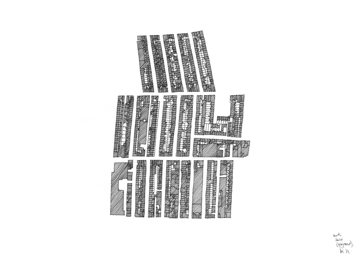
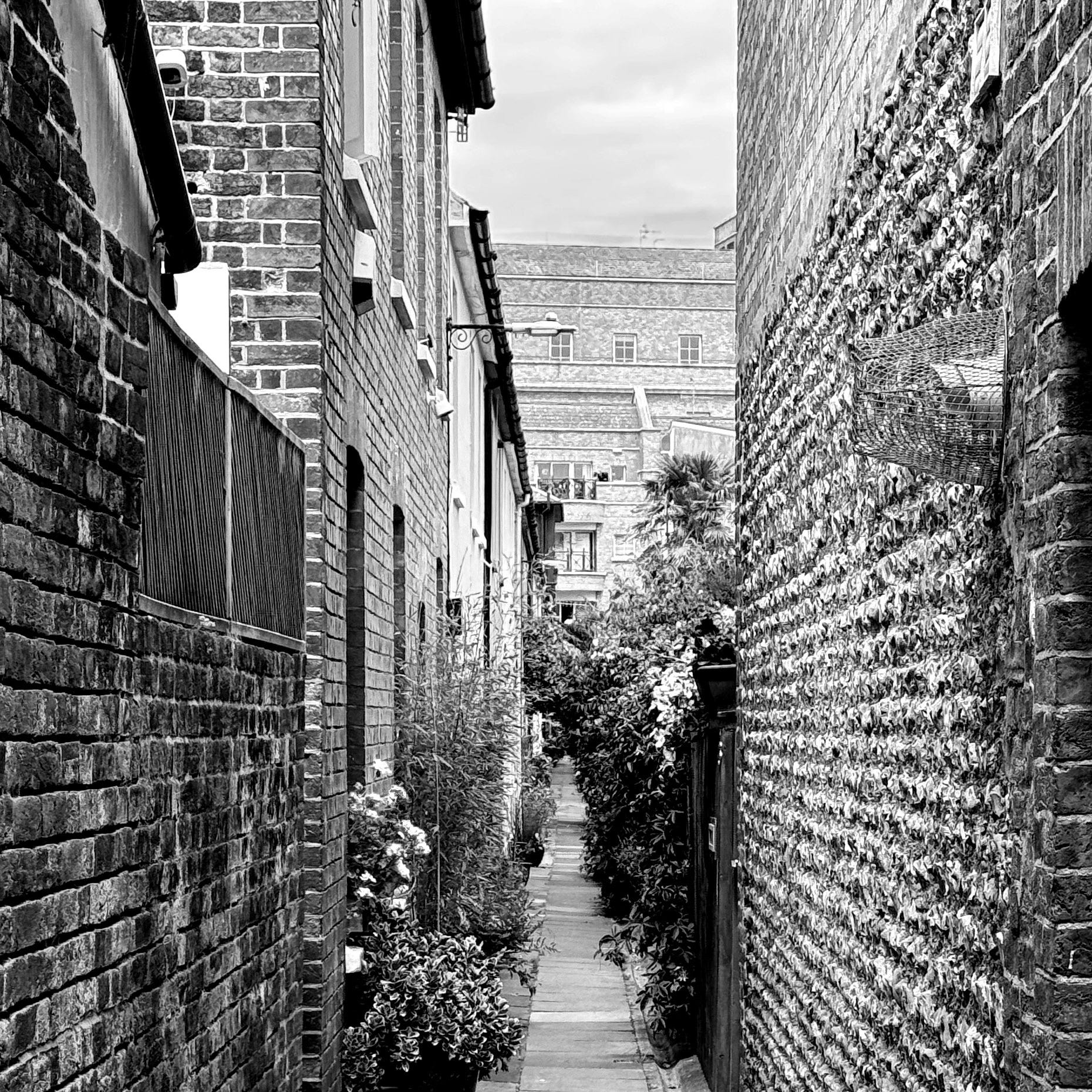
It’s a grid where nothing quite lines up; a rectilinear piece of nineteenth century town which might almost have been rationally-planned with a ruler and straight edge, except… No street leads into another. No street corners are set at ninety degrees. No block is the same size as another. The structure that we might expect – street, front garden, house, rear yard, industry, rear yard, house, front garden, street – is endlessly remixed in seemingly random combinations. Some terraces have generous front yards – and nothing at the back. Some terraces have front gardens separated from the dwelling by a narrow public alleyway. Some streets are wide enough for two-way traffic, others barely wide enough for two-way pedestrians. Some terraces have no frontage onto a street at all. The height averages at 2-3 storeys but varies wildly. And just as it feels like we have established a pattern or a rhythm, suddenly a whole block, as long as a whole street, is occupied by a single industrial use. Not tidied away in the centre of a block, lined or protected from the street by terraces, but just there, filling the block.
Brighton’s North Laine is nineteenth century industrial urbanism overlaid, piecemeal, over a pattern of agricultural land division that had survived since feudal times, and which now survives in the grain of the town. Running steeply down from one of Brighton’s sub-downland slopes, the North Laine was once one of five laines or fields that the worthies of Brighton either farmed themselves or, increasingly over time, divided up in the form of narrow feudal strips for leasing to tenants – the word laine in this context does not describe a thoroughfare but is an Anglo-Saxon word to describe a tenancy or loan. Those narrow strips, known as paul-pieces, were arranged to run parallel to the contour, parallel to the slope, as a way of shoring up the steep agricultural land against soil erosion – like an endlessly sub-divided Douro valley. Each repetitive sequence of paul-pieces was known as a furlong, and these ran counter to the contour, from top to bottom, and between them, also counter to the contour, ran leakways – evocatively-named drainage channels and access tracks. The result of all this was a highly-structured agricultural landscape that not only effectively managed erosion and the flow of water but also, just as importantly, managed individual financial power – the structure meant that no single tenant could claim all of the best land. The best they could manage was a cluster of paul-pieces within a furlong: what became known as a yardland.
By the early nineteenth century the North Laine as a place of agriculture was slowly being overwritten by new industrial uses – industrialised brewing, industrialised milling, industrialised dwelling and industrialsied servitude. Some paul-pieces shifted into terraces of dwellings or commercial premises rapidly, others survived as market gardens for nearly a century, but one by one they shifted from garden to town; gradually developing into rows of terraces, and as their size and angle varied with the terrain and there was no overarching masterplan the hierarchy of streets emerged incrementally, leading to that compelling casual grid where no corner or relation between streets is alike. Similar, but not alike. That’s the success of it – the variation is not wild or extreme, the rules are clear, it’s just that they were laid down for market gardens and then interpreted as a piece of town, with early (1820s) public health legislation forcing, usually but not always, sensible streets in between the paul-pieces, though often the clustered yardlands survived which again contributed to the subtle variations in grid alignment. The leakways of running water became the key lateral streets; what we walk, cycle or drive down now as Trafalgar Street, Gloucester Road, North Road, Church Street. Ironically, though the area’s history as a place of growing survives in street names (Kensington Gardens, Spring Gardens, Frederick Gardens), the furlongs got to the point where they were entirely built-out, and though the networks of streets and leakways make for a highly-successful series of public spaces there is no garden or park of scale. Everything, except for a few industrial uses, was developed at the scale of the terraced house or shop, leading to a repetitive but endlessly varying loose grid in which you always know where you are.
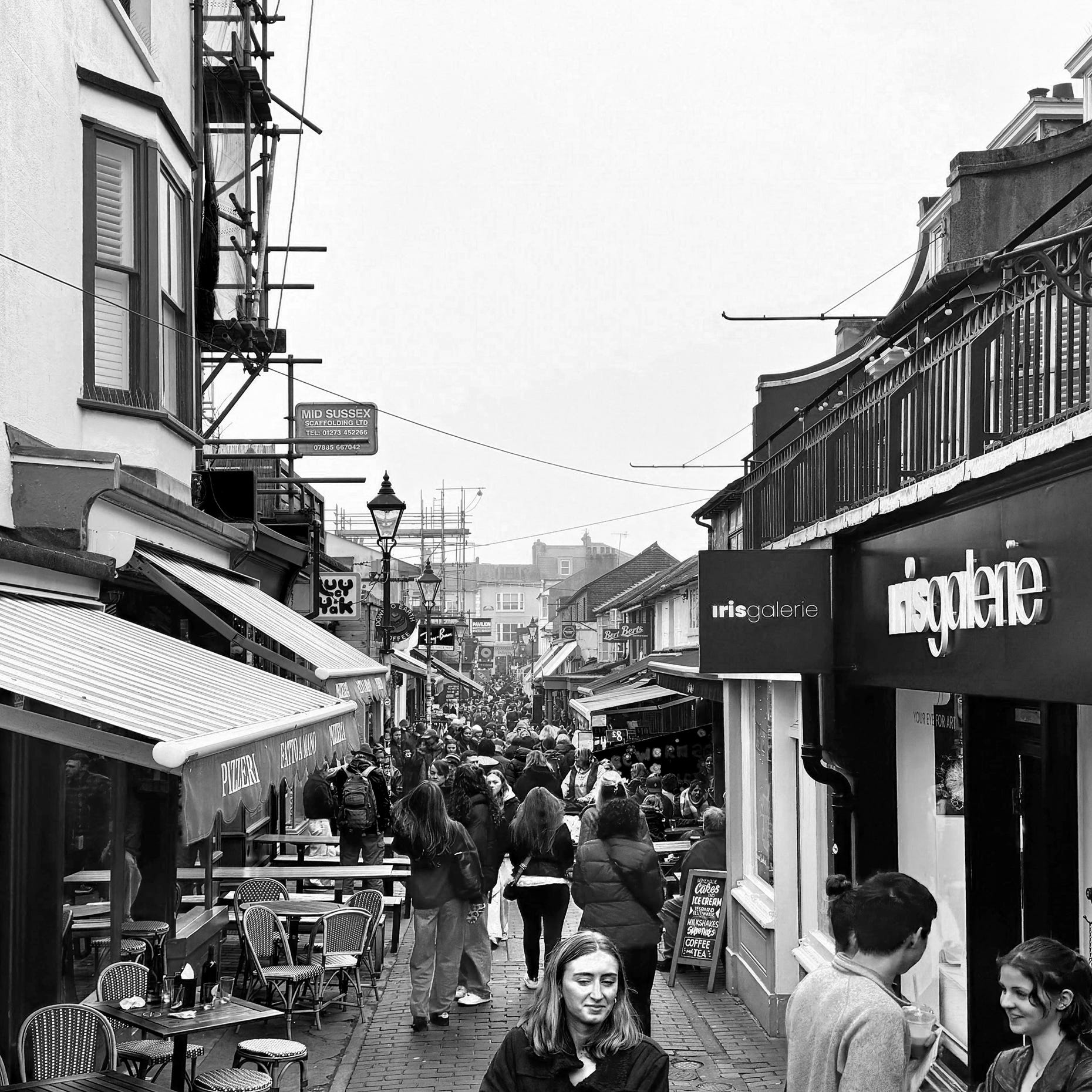
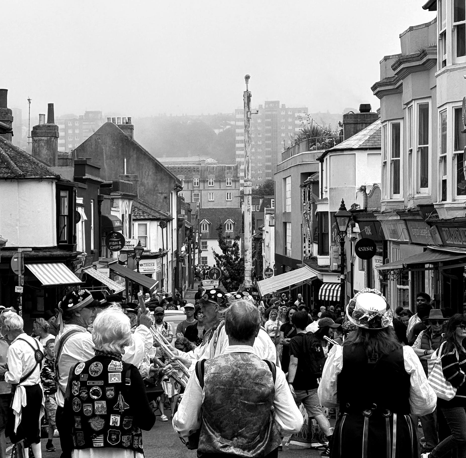
Today, a few biggish lumps of programme have been cut into the grid, not always unsuccessfully: a swimming pool, a library, offices, car parks. These are a reminder that the fine-grain North Laine represented everything that conventional post-war planning practice set itself against , and so of course a raised, multi-lane highway was proposed in 1968 to carve through the centre of it, north to south and terminating in a car park, only being shelved in 1973. The opposition to this scheme (which coincided with outrage over the Greater London Council’s plans for Covent Garden and the publication of the Skeffington Report, which embedded consultation into the planning process) was the impetus behind significant community efforts to designate and preserve the character of the North Laine in a way that we still benefit from today. House prices have predictably soared, even in (or maybe especially in) the terraces with no direct street frontage, but the area’s economic distinctiveness remains more resilient than most, retaining its street and flea markets, its venues, its long-running comic shop, timber yard and legendary food cooperative.
The character of the North Laine, formally informal or informally formal, is the direct result of two ideas of land-division co-existing, or rather of one idea of land-division bending its successor to its will. Underneath, but persisting, we have a feudal, distributed system of agriculture, carefully tuned to the movement of soil and water, and the balancing of individual and collective interest. Overwriting that, yet still defined by what it replaced, we have what would have been a highly repetitive 19th century urbanism, reflecting the inward rush of the labouring classes into the city on the trail of industrial capital, squeezed into that feudal system. What might otherwise have been relentless is instead, as a result of this co-existence or overlay, one of the most satisfying and distinctive pieces of urban form in England.
Since we can’t repeat either of the economic conditions that shaped (and still shape) the North Laine, what can be learned from it in terms of how we might make a town? One is that the overlaying of these two ideas (market gardening vs. dwellings for artisans/servants/fabricators) led, for over a century, to what must have been a brilliantly rich and complex patchwork of dense urban housing and urban agriculture, a quilt of dwelling and growing that feels both beautiful and highly relevant to today. But the main lesson, and the one still visible today, is perhaps that those inconvenient land ownerships, topographic peculiarities or obstructions, those things that apparently frustrate and distort the repetitive grids of our highly-systematised housing products, might just be the disruptive ingredients that turn relentlessness into specificity. To create a piece of town like the North Laine means letting the logic of ‘what’s already there’, however inconvenient, change your plans.
/maps.app.goo.gl/btGGTTKzJMjSQDeZ9
Spitalfields, 23 June 2025.